Travel – St. Paul’s Cathedral

In honor of Sir Christopher Wren (born: October 20, 1632 died: February 25, 1723) this Travel post is about St. Paul’s Cathedral, Wren’s architectural masterpiece and one of the most iconic churches in London, England.  I will begin by discussing the history of the Cathedral and give a brief tour of the interior of the building.  Then to concluded this post, I will briefly discuss the personal and professional life of Sir Christopher Wren who is also responsible for the building of the Royal Naval College at Greenwich and a portion of Hampton Court Palace.

The History of St. Paul’s Cathedral

Dating back centuries ago, the Roman episcopal see (site of a religious leader’s principal church) was located in London on Tower Hill; recent archaeological excavation in 1999 may have revealed the remains of the church.  Then, moving forward a few centuries, a Roman temple dedicated to the goddess Diana was possibly located at the site of the current St. Paul’s Cathedral but there has been no archaeological evidence found to support this theory.  Records indicate that approximately 604 AD the first Anglo-Saxon bishop of London established a church at the same site but it is uncertain what happened to the building after the country reverted back to paganism.  Several centuries passed and the main religion of the country was once again based in Christianity and a new church was built on the site but it was ultimately destroyed in a fire in 962 and rebuilt that same year.  Then, there was another fire in 1087 that severely damaged the existing church.

St Pauls - old photo 2

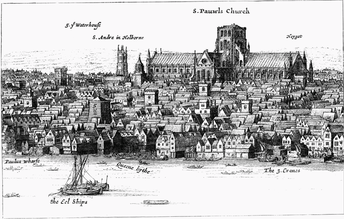
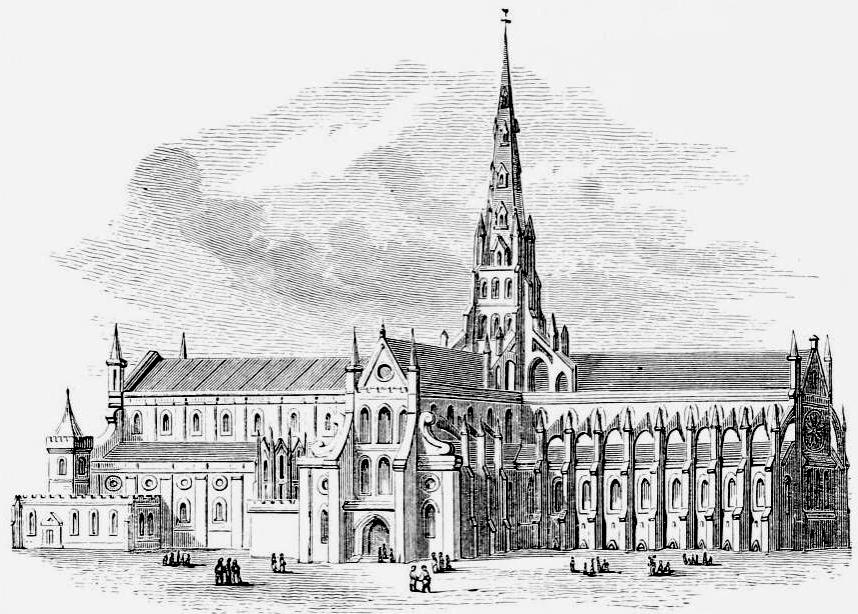
After the 1087 fire, the Normans began repairs to restore the church but unfortunately another fire slowed the restoration.  This church is now referred to as the “Old St. Paul’s” and building’s style of architecture changed from the previous Romanesque to Gothic.  During the reign of King Henry VIII, the ties with the Roman Catholic Church were severed and the newly formed Church of England was established.  King Henry gave the order that all Catholic and Protestant churches and monasteries properties were to be seized by the Crown and either sold or destroyed.  As a result of this order many interior and exterior religious ornamentation was removed from these buildings including St. Paul’s.  (Perhaps ironically, in 1561 lightning destroyed the 489 foot tall spire of St. Paul’s which was interpreted by Protestants and Roman Catholics as a sign from God indicating displeasure directed at the King and the newly formed Church of England)

By 1661, “Old St. Paul’s” was in a severe state of neglect and King Charles II had requested the advice on the extensive repairs required to restore the building from an upcoming architect named Christopher Wren.  Before any significant repairs were started, the Great Fire of London in 1666 swept through the city destroying everything in its path, it is said that in the aftermath of the devastating fire only a third of the buildings remained standing in London.  Following this crisis, Wren was now appointed by the King to oversee the rebuilding of over 50 churches including “Old St. Paul’s”.

Old-St-Pauls

The decision was made that “Old St. Paul’s” would be demolished in 1670 and a new larger cathedral would be built on the site.  Wren’s original design plans for the new cathedral changed several times during the lengthy planning process from a simple building shown in his first drawings in 1669 to a more elaborate design with a grand dome to reflect the importance of the building to the Church of England which were made possible the increase in the building funds through a recently implemented coal tax.  The new St. Paul’s Cathedral was officially completed in 1711.

St Pauls - panorama

Several centuries passed, until the next significant event in the history of St. Paul’s occurred.  On May 7, 1913 St. Paul’s narrowly missed being destroyed by an act of aggression when a bomb was found in the east end of the church under the Bishop’sThrone placed there by members of the Suffragettes.  At this time in history, women in England were literally fighting for the right to vote and unfortunately the actions of the Suffragette organization used to achieve this goal turned violent with various forms of aggressive acts including burning and later bombing of buildings.  Luckily the bomb found in St. Paul’s was able to be defused and ultimately several years later in 1928 the Representation of the People Act gave the right for women to vote.        

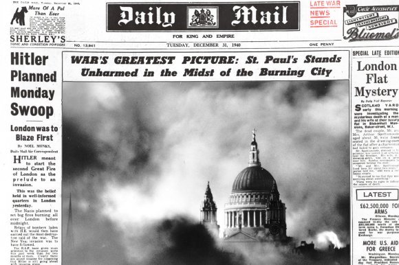
Then, during World War II, German military planes attacked England in a series of devastating bombings which became known at the Blitz.  On the night of December 29, 1940 the German planes destroyed the area surrounding St. Paul’s Cathedral, but the building miraculously survived!  A famous photograph by Herbert Mason was taken the morning after the attack and was featured on the front page of the Daily Mail.  The picture, which became known as “St. Paul’s Survives”, shows the dome of the Cathedral illuminated by the searchlights with the smoke from the burning buildings rising into the sky. 

St Pauls - Blitz bombing newspaper

A Brief Tour of St. Paul’s Cathedral

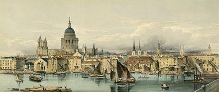
St. Paul’s Cathedral was designed by Christopher Wren in a Baroque style of architecture and is built on Ludgate Hill which is the highest point in London.  The Cathedral building is 574 feet long and 227 feet wide, the two bell towers are 212 feet high and the spectacular dome is 365 feet high.

The ground of Ludgate Hill was formed of soft clay soil and this was a considerable challenge for Wren when he was planning and designing the rebuilding of St. Paul’s in the late 17th century.  To support the massive Cathedral a large area was excavated, this would eventually become the crypt.  Inside this part of the Cathedral large piers were erected to support and evenly distribute the weight of the new Cathedral.

Exterior of St. Paul’s Cathedral –

The magnificent Dome of St. Paul’s Cathedral is constructed with layers consisting of the exterior dome and the decorative interior dome.  Between the exterior and the interior domes is a brick cone 18 inches thick which provides support for the heavy leaded exterior dome and the stone lantern at the top.   To provide additional support for the exterior dome, Wren designed a series of columns which create an open colonnade that encircles the base of the exterior dome allowing it to soar to the height of 95 feet, the columns also serve to support the inner dome and the brick cone located inside the building to support the Lantern section.  The 850 ton Lantern rises above the dome in several sections; the first section is square in shape, the second section is the tallest and is formed with four columns each facing in the direction the main points of a compass and the third section is topped with a small dome which rises into a golden ball and cross.  In 1708, Christopher Wren, Sr. was 76 years old and unable to place the final stone of the Lantern so it was done by his son Christopher Wren, Jr. who had also become an architect and assisted his father in the final stages of building St. Paul’s.  (Special Note: Several centuries later, in 1996 an extensive restoration project of St. Paul’s dome involving copper, lead and slate work and it took 15 years to complete and was finished in June 2011)

St Pauls - exterior 1

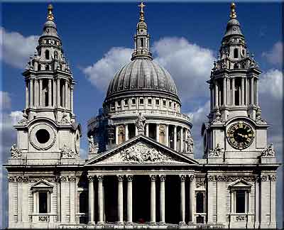
The West Front of St. Paul’s is considered the main entrance and has a columned portico which is topped by an upper columned colonnade; it is topped by the pediment which features a bas-relief sculpture known as the Conversion of St. Paul by Francis Bird.  Above the pediment is the statue of Saint Paul in the center with statues of Saint James and Saint Peter on either side.  Two Baroque-style bell towers, known as the West Towers, frame the portico on either side.  The southwest tower holds the clock known as “Big Tom”; made by John Smith and installed in 1893, the bell connected to the clock is known as “Great Tom”.  The northwest tower holds a set of 12 bells, the largest is known as the “Great Paul” bell originally cast in 1882, it the largest bell in England and weights almost 17 tons.

St Pauls - west front

Interior of St. Paul’s Cathedral –

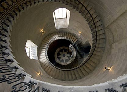
As visitors enter St. Paul’s Cathedral they will see the 30 feet high Great West Door which is only opened for special occasions.  After passing through the vestibule, to the left is the Chapel of St. Dunstan dedicated to the former Bishop of London and Archbishop of Canterbury and located near the northwest door is the All Soul’s Chapel dedicated to Field Marshal Lord Kitchener and all the British serviceman who lost their lives in World War I.  To the right is the Chapel of St. Michael and St. George and located near the southwest door is the Geometrical Staircase.  (Shown below is a photo of the Geometrical Staircase and it may look familiar to fans of the Harry Potter movies.  Check out the interesting facts sections below to find out more information!)

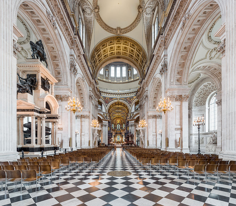
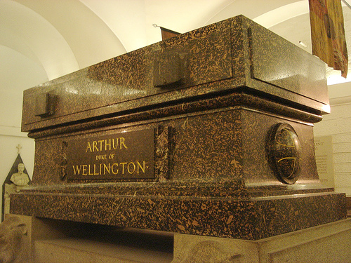
Located directly ahead is the Nave which is 223 feet long and 121 feet wide with a ceiling that soars to the height of 91 feet.  The black and white marble floor was laid by William Dickinson and completed in 1710.  Several piers decorated with Corinthian pilasters separate the Nave from the north and the south aisles.  Special Note: Located halfway down the north aisle is the Wellington Monument.  (More information about the Wellington Monument can be found in the interest facts section later in this post) 

Wellington Mounment

At the end of the Nave there is a wide area that bisects this part of the Cathedral forming a cross which was commonly used in the design of churches throughout the years, this area measures approximately 246 feet wide from the North Transept to the South Transept.  One item of note is located in the North Transept and it is the Italian marble baptismal Font which dates back to 1727.  Then, in the South Transept visitors can access two sets of stairs, one leads down into the Crypt and the other staircase allows visitors to climb to the Whispering Gallery for one of the best views of the Dome, there are 259 steps from the floor of the Nave to the Whispering Gallery.  For the more adventurous visitors, they can climb 117 steps further to the Stone Gallery which goes round the outside of the Dome and then an additional 166 steps to the Golden Gallery into the Lantern located at the top of the Dome.  (Shown below are two photos; the first is taken from the center of St. Paul’s looking back toward the Nave and the second is looking forward to the choir and the high altar)

Center - looking back at the NaveCenter - looking towards the nave

As visitors look down from the Whispering Gallery they will see the flooring of the Cathedral in the Transept area directly below the Dome, it is decorated with an intricate pattern made with colored marble ti

les.  At the center is a large brass grill which had an interesting function during the 19th century, it was used for heating St. Paul’s.  Stoves were lit in the Crypt area below the main floor and hot air would rise up through the metal grating and heat this area of St. Paul’s, other similar but small grates can be found in other areas of the Cathedral.  Circling the grate is a section of flooring with a Latin inscription which pays tribute to the builder of St. Paul’s Cathedral, Christopher Wren.  (Below is a photo of the Transept area as seen from the Whispering Gallery)

Whispering Gallery

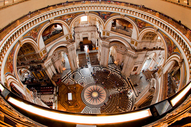
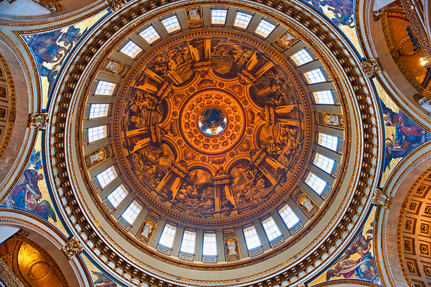
From the Transept area of the Cathedral, visitors can look up to see the great Dome of St. Paul’s and at almost 65,000 tons it is one of the largest in the world.  The magnificent Dome of St. Paul’s raises high above the main floor of the Cathedral supported by eight piers made of Dorset stone with eight arches used to evenly disperse the weight of the massive dome, located within the niches are several statues.  The interior Dome features a beautiful fresco painting by James Thornhill which depicts eight scenes from the life of St. Paul; it was started in 1716 and completed three years later in 1719.  The upper area of the Dome is lit by openings in the outer Dome and the brick cones which are both used to support the weight of the interior Dome.  At the apex of the Dome is an oculus, a round opening, and through which visitors will be able to see the decorated interior cone that supports the Lantern.

St Pauls - dome

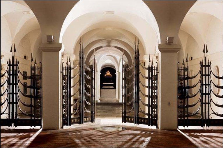
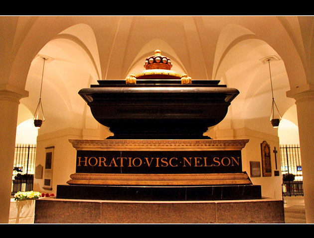
For this tour of St. Paul’s, we are going to take a side trip down into the Crypt which can be access through a staircase in the South Transept.  As visitors enter the Crypt, overhead is a carving that depicts the faces of death which is a grim reminder that this section of the Cathedral is a burial place.  The St. Paul’s Crypt is the largest one in Europe and visitors will find numerous tombs: such as those of Christopher Wren, the Duke of Wellington and Admiral Nelson.  In the farthest section of the Crypt is the Chapel of the Order of the British Empire and it was dedicated to Queen Elizabeth II and the Duke of Edinburgh in 1960.  Also located in the Crypt is the Treasury Room which displays some of the items that have been used within the Cathedral over the centuries and a small gift shop for those visitors wishing to buy souvenirs.

St Pauls - crypt

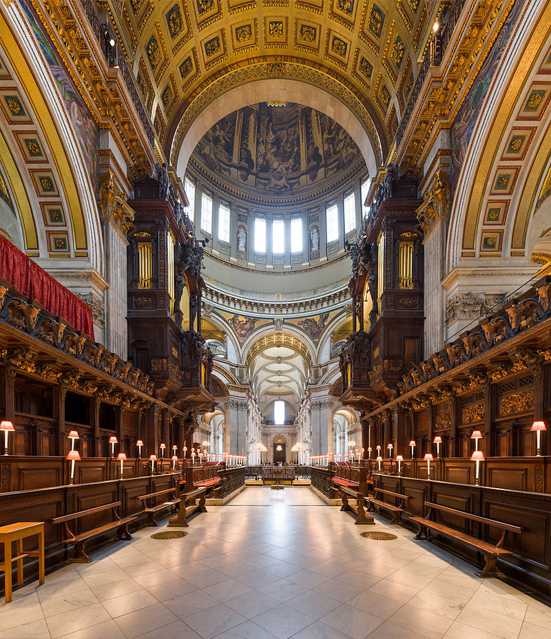
Back to the main floor of the Cathedral, we will continue the tour into eastern portion of the building where the Quire, the Choir, High Altar and the Apse are located.  The Quire forms the upper portion of the cross shape of the building and it is the most elaborately decorated area of the Cathedral.  As visitors proceed into the Quire, please be sure to look up to the beautiful ceiling which is a series of three smaller domes which depict creation and is created with intricate mosaics of birds, fishes, cattle and other animals of the earth. A frieze surrounding the ceiling of the Quire depicts Adam and Eve in the Garden of Eden with several more animals; such as tigers, lions, panthers and peacocks.

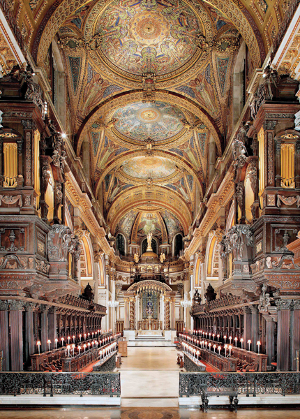
The Choir area of the Cathedral holds the beautiful carved organ and wooden stalls used by the clergy and the choir during the religious service.  The large organ located near the Transepts was commissioned with Bernard Smith and installed in 1695.  It is one of the largest organs in England with a console of five keyboards and there are 138 stops that operate 7,189 pipes, the working of the organ are enclosed in a wooden case designed by Wren and wonderfully carved by the famous Grinling Gibbons.  Also located in the Choir area is the brass eagle lectern made by Jacob Sutton in 1719 and on the other side is a carved oak pulpit which was installed in 1964 to celebrate the 250th anniversary of the completion of the Cathedral.  The Choir Stalls were also carved in oak by Grinling Gibbons and the Bishop’s Throne is decorated with carved wooden floral garlands, winged cherubs and the arms of the Bishop. 

St Pauls - organ

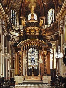
Located near the High Altar are the Tijou Gates and balustrades created in an intricate design of wrought iron by the French metal worker Jean Tijou.  The High Altar is based on original sketches by Wren and featured in this 20th century version is the beautifully carved slab of Italian marble that weighs nearly four tons and was commissioned by the British people after the previous one was damaged in the German Blitz, it is a memorial to those that lost their lives in World War II.  Placed on the High Altar is a large cross that stands nearly 10 feet tall with a silver enameled base embellished with amethyst and flanked by two five feet tall gilded candlesticks.  The High Altar is covered by a large carved oak canopy that was installed in 1958.  (Special Note: Located in the south Choir aisle in the Lady Chapel is a statue of poet John Donne which is the only item from the “Old St. Paul’s” that survived the Great Fire of 1666.  

altar Interesting facts about St. Paul’s Cathedral

  • “Borrow from Peter to pay Paul” – One explanation of this old English saying goes back to before King Henry VII broke ties with the Catholic Church of Rome to form the Church of England.  It is said that in order to pay the church taxes to St. Paul’s in London the funds were not paid to St. Peter’s in Rome.  Another explanation originated back to the 16th century when the money intended for St. Peter’s in Westminster was used to pay for repairs to St Paul’s in London.
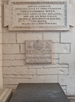
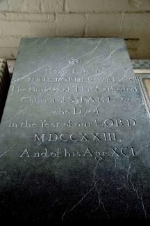
  • Christopher Wren tomb – Sir Christopher Wren the English architect who designed St. Paul’s Cathedral is buried in the Crypt.  On the wall next to the grave there is a plaque written in Latin that reads: “Here in its foundations lies the architect of this church and city, Christopher Wren, who lived beyond ninety years, not for his own profit but for the public good. Reader, if you seek his monument – look around you. Died 25 Feb. 1723”.  This same epitaph is repeated in the flooring of the Transept area as previously mentioned.  (For more information about the personal and professional life of Sir Christopher Wren, please see the last section of this post)

St Pauls - Christopher Wren 1  St Pauls - Christopher Wren 2

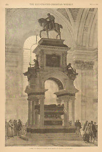
  • Lord Horatio Nelson tomb – Lord Nelson (September 29, 1758 – October 21, 1805) Vice Admiral of the British Navy died heroically at the Battle of Trafalgar and he is buried in the center of the crypt directly beneath the dome of St. Paul’s Cathedral.  His funeral procession had over 32 admirals and an escort of 10,000 servicemen who progressed through the streets of London to St. Paul’s, he was buried within a stone sarcophagus that was originally carved for Cardinal Wolsey.  The sailors that were in charge of folding the flag that covered Nelson’s coffin and then placing it in the grave instead tore it into fragments to keep as a memento.

St Pauls - Nelson

  • Arthur Wellesley, the 1st Duke of Wellington tomb – Wellington (May 1, 1769 – September 14, 1852) the former Prime Minister of the United Kingdom was given a state funeral which is normally reserved for British Royalty but on occasion a high ranking British subject can be given the honor.  It is said that almost 1 million people watched the Duke’s funeral procession to St Paul’s before he was interred in a luxulyanite (a type of granite) sarcophagus.  Wellington’s final resting place was decorated with banners from various European countries which were specially made for his funeral procession, during World War I the banner of Prussia was removed and never replaced.  Located between the Nave and the North Aisle of St Paul’s is a massive bronze and stone memorial was sculpted by Alfred Stevens and features at the top a figure of Wellington on his horse and farther before two sets of statues representing valor defeating cowardice, truth over falsehood.

St Pauls - Wellington

  • Sir Winston Churchill memorial – The State funeral for Sir Winston Churchill (November 30, 1874 – January 24, 1965) the former Prime Minister of the United Kingdom was held at St Paul’s Cathedral on January 30, 1965, it was broadcast both on radio and television in England.  There is a bronze memorial plaque that marks the spot in St. Paul’s at the Quire steps where the catafalque was placed during the funeral service, it was designed by John Skelton.  There is also the Winston Churchill Memorial Screen located in the crypt, it was designed and made by the blacksmith James Horrobin in 2004.  Churchill’s final resting place is not within St. Paul’s but at St Martin’s Church in Bladon in Oxfordshire, England, located nearby is Churchill’s birthplace and ancestral home of Blenheim Palace.  (For more information about Blenheim Palace, please click on the link)

Churchill funeral 1a

  • 1981 Royal Wedding – Charles, Prince of Wales, married Lady Diana Spencer in a grand Royal Wedding on July 29 1981 at St Paul’s Cathedral, it became known as the “wedding of the century”.  Since it was the marriage of the heir to the British throne St. Paul’s was chosen as the venue instead of the Westminster Abbey because it would hold the 3,500 guests.  (For more information regarding the Royal wedding of Prince Charles and Diana the Princess of Wales, please click on the link to Royal Weddings – Part Four post)

Royal Wedding

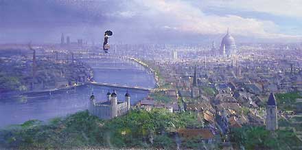
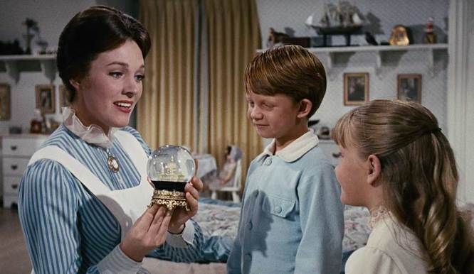
  • Mary Poppins – St. Paul’s Cathedral was featured in several scenes in Disney’s 1964 film, “Mary Poppins”.  At the beginning of the movie, Mary Poppins is seen flying over the city of London and the beautiful dome of St. Paul’s designed by Wren is shown dominating the skyline. Then, in another scene, Mary Poppins holds a snow globe that features a miniature St. Paul’s Cathedral and she is about to tell the children the story of the Bird Woman who sells crumbs for “tuppence a bag”.  As she begins singing the song, “Feed the Birds”, the scene changes from the Bank’s house to the top of St. Paul’s and pans down the front of the church to the Bird Woman sitting on the steps surrounded by the birds she is feeding.  (For more information on Mary Poppins – the book, movie and play, please click on the link)

practicallyperfect  Mary-Poppins-St Pauls snowglobe
mary-poppins-feed-the-birds 1Harry Potter and the Prisoner of Azkaban – The third movie in the Harry Potter series of films is the 2004 “Prisoner of Azkaban”.  The Warner Brother’s film features the Geometric Staircase which is located in the South West Bell Tower of St. Paul’s Cathedral.  In the movie, the students of Hogwart’s need to climb to the top of the “Divination Staircase” to gain access to Professor Trelawney’s Divination classroom.  (For more information about the Harry Potter book series, please click on the link to J.K. Rowling)

St. Pauls - Harry Potter Divination Stairwell

The Personal and Professional Life of Sir Christopher Wren

Christopher Wren (October 20, 1632 – February 25, 1723) the acclaimed architect of St. Paul’s Cathedral also designed the Royal Naval College at Greenwich and a portion of Hampton Court Palace as well as overseeing the rebuilding of 52 churches in London after the Great Fire of 1666.

Christopher_Wren_by_Godfrey_Kneller_1711

Christopher Wren was born in East Knoyle in Wiltshire, England.  His father, Christopher Wren Sr., was a rector in East Knoyle and his mother was Mary Cox who died when Wren was a small boy.  In March 1635, Wren Sr. became the Dean of Windsor and they spent part of each year there.  Little is known about Wren’s early education except that he was tutored by Rev. William Shepherd and possibly attended the Westminster School, he also studied mathematics under the guidance of his brother-in-law, Dr. William Holder.

In June 1650, Wren entered Wadham College in Oxford where he studied a variety of subjects such as Latin, mathematics and science. Wren graduated in 1651 with a B.A. and a M.A. in 1653.  In 1657, Wren became a Professor of Astronomy at Gresham College located in London and later a Savilian Professor of Astronomy at Oxford.  Wren also continued to meet with a group of mathematics, scientists and philosophers that he had meet through his association with John Wilkins, the Warden of Wadham College.  By 1660, these weekly meetings eventually evolved into the beginning of the Royal Society of London and in 1662 they were granted a royal charter by King Charles II.  Wren played an important role in the early years of the organization due to his expertise on a variety of subjects (ranging from general medicine, astronomy, meteorology and mechanics) which was helpful in motivating the exchange of ideas between the various groups of scientists.

Wren had been developing an interest in architecture as a form of applied mathematics since his years as a student in Oxford.  Then in 1661, through his connection with the Royal Society, King Charles II became aware of Wren’s work and he requested his advice on the extensive repairs that St. Paul’s Cathedral required after many years of neglect.  Coincidentally, during a trip to Paris, France in 1665, Wren became inspired by the works of Gian Lorenzo Bernini, the famous Italian architect of St. Peter’s Basilica in the Vatican City.  It was shortly after returning home from Paris that the city of London was almost entirely destroyed by the Great Fire of September 1666.  Wren was appointed by the King to oversee the rebuilding of 51 churches and one of those was the great St. Paul’s Cathedral.

In regards to Wren’s architectural career, St. Paul’s Cathedral took about 36 years from the start of the rebuilding in 1667 to its completion in 1711.  Wren left the teaching profession and was now a fully established architect.  Other major architectural commissions included the Royal Observatory in Greenwich (1675-76), the Wren Library at Trinity College in Cambridge (1676-84), the Chelsea Hospital (1682-92) the reconstruction of the state rooms at Windsor Castle, a new chapel and Queen’s apartments at Whitehall (1685-87), various rooms at Kensington Palace (1689-96) and a large addition to Hampton Court (1689-1700).  In addition, Wren was appointed Surveyor the Greenwich Naval Hospital in 1696 and the Surveyor of Westminster Abbey in 1698.

On a personal note, Wren waited until the age of 37 before he married Faith Coghill in 1669, they had two children.  Gilbert was born in 1672 but died at the age of 18 months old and Christopher was born in 1675 but sadly later that same year Faith died of smallpox.  Christopher was sent to live with Faith’s mother in Oxfordshire for a period of time.  Then, in 1677 Wren married Jane Fitzwilliam and they had two children, a daughter named Jane born in 1677 and died in 1702 and a son William born in 1679.  His second marriage was also very brief and Jane died of tuberculosis in 1680.  In lieu of salary owed for part of his work on the building of St. Paul’s, Wren was given a home near Hampton Court and he also leased a house located on St. James Street in London.  Wren died at the age of ninety-one at his home in London and he is buried in the crypt of St. Paul’s Cathedral.

Travel – Yosemite National Park (Part Two)

Yosemite National Park

Yosemite National Park is located in the state of California on the western portion of the Sierra Nevada Mountains ranging in elevation from 2,127 to 13,114 feet.  The park covers almost 1190 square miles but most of the 3.5 million annual visitors spend the majority of their time in the seven square miles of Yosemite Valley.  Visitors to Yosemite National Park will see the majestic El Capitan and Half Dome granite formations and a several waterfalls, such as Yosemite Falls and Bridalveil Fall, the beautiful open space of Tuolumne Meadows and the massive giant sequoia trees of the Mariposa Grove.

In Part One, of the two part series on Yosemite National Park, I discussed the history of the park throughout the years, please click on the link to Yosemite National Park (Part One).  In Part Two, I will discuss Yosemite visitor information and give a list of suggested places to see and things to see and do.

Yosemite National Park Visitor Information

Tips and suggestions for planning a visit to the park

  • I always recommend when visiting any of our National Parks, it is a good idea to start at the Visitor Center where visitors can get maps, brochures, hiking permits and current weather information or road closures.  Also be sure to check the schedule of Ranger presentations or guided hikes which are a great source of information about the park.

Yosemite Visitor Center

  • For general information on Yosemite National Park please click on the link to their website www.nps.gov/yose for the most accurate information regarding Visitor Center hours, wilderness permits, road closures or other park restrictions.
  • Once you have determined the time of year you will be visiting the park, be sure to make reservations as far in advance as possible especially during the summer months, Memorial Day to Labor Day.  (Please click on the individual hotel and cabin accommodations website links mentioned in this post for more specific information regarding prices and availability)
  • Yosemite National Park has several campgrounds and reservations are required from March through November.  Campground reservations can be made up to five months in advance, on the 15th of each month at 7 am Pacific time. Be aware that nearly all reservations for the months of May through September are filled the first day they become available.  Click on the link www.recreation.gov for more complete information.
  • When visiting Yosemite Valley consider parking the car at your hotel, cabin or campground and take the readily available Yosemite shuttle buses which stop at all the major sites in the Valley. 
  • Bikes are another great alternative driving your car and an excellent way to avoid traffic congestion in the Valley especially during the summer months.  You can bring your own bikes or rentals are also available, there are 12 miles of paved trails in the Valley, be sure to bring bike locks.  Please be advised that mountain biking off the trails is not allowed.
  • Rock Climbing has become an important part of the history of Yosemite; El Capitan is one of the most challenging mountains in the world.  Various companies in the Valley offer a variety of classes from novice to experienced climbers.  (For more information about El Capitan can be found later in this post)
  • There are over 800 miles of hiking trails in Yosemite National Park ranging from easy trails that take under an hour, medium trails that can take a couple of hours  and strenuous trails that can be a multiple day backpack adventure such as the John Muir Trail (which require a wilderness permit).  Be prepared and check out the trails in advance, information is available at any of the park’s visitor centers.  (obviously multi-day backpack trips are for the more experienced hikers and will take much more preparation, such as obtaining bear-resistant food storage containers.)
  • When hiking stay on established trails, observe posted warning signs, carry water to stay hydrated and bring along snacks, stop occasionally and rest in the shade; and eat salty snacks.

Places to see in Yosemite National Park

Wawona Tunnel View –

Most visitors that come to Yosemite National Park arrive in Yosemite Valley through the Wawona Tunnel via California Highway 140 (El Portal Road).  The Wawona Tunnel built through solid granite was completed in 1933 is 4,233 feet long making it the longest tunnel in California.  After passing through the tunnel, visitors should stop at the Tunnel View Overlook for a wonderful view of Yosemite Valley.  As you look out into the Valley from the overlook El Capitan is to the left, to the right is Bridalveil Fall and at the far end of the Valley is Half Dome.

Yosemite Valley 1

Yosemite Valley –

Yosemite Valley is the destination for most visitors coming to Yosemite National Park, it is open year-round.  The numerous activities in the Valley include hiking the various trails, rafting down the Merced River, biking, horseback riding, rock climbing and ranger-led nature walks.

El Capitan –

El Capitan is the granite monolith (a large single vertical rock formation) located at the north-west end of Yosemite Valley; it is 3,000 feet from base to summit.  The Ahwanhneechee Native Americans called it “Totokonoolah” and the Mariposa Battalion translated the name into El Capitan.  (Historic Fact: The Mariposa Battalion came to the area in 1851 and they were given the ominous task of removing the Native Americans from Yosemite Valley)

El Capitan

El Capitan is a popular destination for rock climbers, there is also a trail located near Yosemite Falls that can be used to reach the summit.  El Capitan was once considered impossible to climb until 1958 when a trio of climbers named Warren Harding, Wayne Merry and George Whitmore reached the summit of an area known as “The Nose” in 47 days using rope, pitons and expansion bolts.  Throughout the years other routes on the face of El Capitan were created and also new techniques and equipment were developed to make the ascent times faster.

Yosemite National Park Trivia:  El Capitan was used as the filming location for the 1989 “Star Trek – the Final Frontier” movie.  The scene shows Captain Kirk, played by William Shatner, on shore leave from the Starship Enterprise scaling the face of El Capitan, he loses his grip on the mountain and starts to plummet to the ground but is saved by Spock, played by Leonard Nimoy.  Shatner trained for several weeks on the Paramount lot for the close-up shots and stunt doubles for the long shots.  For the scene of Spock floating in the air in his levitation boots as he talks to Captain Kirk, Nimoy stood on top of a crane.

El Capitan and Captain Kirk in Star Trek movie Final Frontier

Bridalveil Fall –

Bridalveil Fall is the first waterfall visitors will see upon entering Yosemite Valley, it is located in the south-west area of the Valley.  Bridalveil Fall is 620 feet in height and in the spring the fall usually runs very full but later in the year it slows to a small trickle.  From the parking lot, there is a paved trail to reach the base of the fall and the viewing platform; use caution when reaching the base, the paved trail can be very wet and slippery.  HAZARD WARNING: DO NOT LEAVE THE TRAIL TO CLIMB THE ROCKS AT THE BASE OF THE WATERFALL!!

Bridal Veil Falls

Yosemite Falls –

Yosemite Falls is located at a point midway through the Yosemite Valley on the north-side; the total length is 2,425 feet from the top of the upper fall to the base of the lower fall.  The waterfall plunges from Yosemite Creek to the floor of the valley; the Upper Yosemite Fall is 1,430 feet, the Middle Cascades is a section with five separate plunges for a total of 675 feet and the Lower Yosemite Falls is 320 feet.  The Yosemite Creek continues from the base of the waterfall and flows into the Merced River that runs through the length of the Valley.  HAZARD WARNING: DO NOT LEAVE THE TRAIL TO CLIMB THE ROCKS AT THE BASE OF THE WATERFALL!!

Yosemite Falls 2

Half Dome –

Half Dome is the granite dome located at the east end of Yosemite Valley, the summit rises 4,737 feet.  Much like El Capitan at the other end of the Valley, Half Dome was thought to be impossible to climb.  In 1875, George Anderson was able to climb to the summit by constructing a path by drilling and then placing iron bolts into the granite “back” or east side.  Today, visitors hike the 8.2 mile Mist Trail, past Vernal and Nevada Falls, to reach the base of Half Dome.  Then visitors climb the rounded east side via a set of steel cables to reach the summit, the cables are fixed with bolts on a series of metal poles leading from the base to the summit and are installed from late May to early October.  Permits need to be arranged in advance before entering the park, a ranger will check permits on the trail and hikers without the proper permit will not be allowed beyond the base.  Hikers caught bypassing the rangers will fined or receive possible jail time.

Half Dome  Half Dome - warning 2

Half Dome - cables

PLEASE BE ADVISED: THE NATIONAL PARK SERVICE RECOMMENDS AGAINST CLIMBING THE HALF DOME ROUTE WHEN THE CABLES ARE DOWN OR DURING BAD WEATHER CONDITIONS OR WHEN LIGHTNING STRIKES ARE OCCURRING IN THE VICINITY.

Native American Legend:  The Ahwahneechee Native Americans called Half Dome by another name, “Tis-sa-ack”.  The legend goes that Tissaack, a Native American woman and her husband Nangas lived far away from Yosemite on the Great Plains of America.  The couple traveled to Yosemite over the rugged terrain of the Sierra Mountains until finally arriving a few days later in Yosemite Valley.  But when they arrived, Nangas was feeling thirsty, hungry and short tempered, and he unexpectedly struck Tissaack and she became frightened and ran eastward back through the Valley to get away from him.  The gods were looking down on the couple that was disturbing the peace of the Valley and intended for them to stop; as a result the gods changed Nangas into the rock formation known today as Washington Column and Tissaack into Half Dome.  It is said the dark streaks on the face of Half Dome are the tears of Tissaack but they are in fact patches of brown lichens that has formed in the dark vertical grooves of the rock formation.

Half Dome 1

Vernal Fall / Nevada Fall –

The Mist Trail which travels along a path that takes visitors past two waterfalls, Vernal and Nevada Falls.  The trail can sometimes be a strenuous climb to the top and sections of the trail can be closes during late fall and winter depending on snow and icy conditions.  The first section of the trail starts at the Happy Isle parking lot and is paved to the Vernal Fall footbridge.  The trail can get very crowded in the summer months, keep to the right climbing up and the left climbing down.  From the footbridge visitors will have a good view of Vernal Fall, then proceed up a steep 600 step granite stairway, but be careful because the pathway can be wet and slippery from the spray of the waterfall.  At the top of Vernal Fall, visitors can look straight down the length of the 317 foot waterfall.

Just past Vernal Fall is Emerald Pool, please keep in mind that it is dangerous to swim in the pool due to the extremely hazardous current as the water moves down from Nevada Fall and continues down to Vernal Fall.  As the Mist Trail continues the steep and rocky switchbacks that climb another 1.5 miles up to Nevada Fall.  There is a footbridge at the top that crosses Nevada Fall as it thunders down 594 feet.  There are several options that can be accessed from this part of the trail.  Visitors can return down the same route in which they climb up (2.5 miles) or they can join the John Muir Trail for an alternate route back to Yosemite Valley (4 miles).

DANGEROUS CONDITIONS CAN EXIST WITH WET AND SLIPPERY AREAS ALONG THE MIST TRAIL.  PLEASE OBSERVE ALL WARNING SIGNS AND DO NOT CROSS OVER RAILINGS OR ENTER THE WATER, THE CURRENT CAN BE VERY STRONG AND EXTREMELY DANGEROUS.

Curry Village –

Curry Village has a very long history in the Yosemite Valley; it was originally founded in 1899 by David and Jennie Curry.  When the couple, who were two schoolteachers from Indiana, decided to visit the park they found that they could barely afford the transportation and the park lodgings.  So, as a result of their dilemma they established Camp Curry in 1899 which started as several canvas tents and a communal dining room for their guests.  Not only was Camp Curry the most affordable accommodation within the Yosemite Valley but the Curry’s thought that entertainment was also a key to their success.  So, throughout the years Camp Curry has featured a dance hall, nightly movies, a soda fountain, a swimming pool during the spring and summer months and an ice skating rink in the winter but the most famous nightly entertainment was the Yosemite FireFall.  The dozen tents expanded into over a hundred and additional wooden cabins were also built and later the dance hall was converted into the Stoneman House lodge with 18 rooms.  For more information about the Camp Curry facility and activities or to book a reservation for a stay in Yosemite Valley, please click on the link to their website at  www.yosemitepark.com/curry-village.aspx

Camp Curry Curry Village - tents

Historical Note: The Yosemite Firefall was a nightly summer time event that began in 1872 and for almost one hundred years, interrupted only during the World War II, until the event continued until 1968.  From the top of Glacier Point in Yosemite National Park, the owner of the Glacier Point Hotel would start the event on the signal “Let the fire fall” from David Curry, the owner of Curry Village that was located 3,000 below in Yosemite Valley.  Hot embers from a huge bonfire at Glacier Point would be pushed off the edge giving the appearance of a glowing waterfall in the night as the “Indian Love Call” song was played creating a very dramatic mood; the spectacle would conclude the evening program at Camp Curry.  In the mid-1960s, the National Park Service was in the midst of changing their policy to eliminate unnatural activities from the parks and the order was given to stop the nightly Yosemite Firefall.  Not only was it a potentially dangerous activity but the surrounding meadows near Camp Curry would be trampled every night with visitors gathering to catch a glimpse of the event.  A year after the last Firefall in January 1968, the Glacier Point Hotel was standing vacant due to sustained damage from an unusually heavy snowfall that winter and an electrical fire in July 1969 burned down the hotel and it was never rebuilt.

Curry Camp - Firefall 2

Yosemite Lodge at the Falls –

Formerly known as the Yosemite Lodge, the name was changed in the mid 2000s to reflect the hotel’s close proximity to Yosemite Falls located just 0.5 miles away.  “The Lodge” is a moderately priced hotel with a total of 249 rooms spread out across the property in 15 separate buildings which are named after various flowers and trees that can be found in Yosemite National Park.  The hotel was once a larger complex but the devastating flood of the Merced River in January 1997 destroyed over half of the pre-existing rooms and cabins.  (Travel Tip: Book hotel reservations as far in advance as possible especially if a visit is planned during the busy summer months)  To book a room at the Yosemite Lodge at the Falls, please click on the link to their website at www.yosemitepark.com/yosemite-lodge.aspx

Yosemite Lodge - entrance

Ahwanhee Hotel –

The Ahwanhee Hotel is the premiere grand hotel in Yosemite National Park; it is the highest priced accommodations in the park with 123 beautifully decorated rooms in the hotel and 24 luxury cabins.  To book a room at the Ahwanhee, please click on the link to their website at www.yosemitepark.com/ahwahnee-accommodations.aspx.  (For more information regarding the history of the Ahwanhee Hotel and the annual Bracebridge which is held at the hotel every Christmas season since 1927, please click on the link)

Ahwahnee Lodge 1

Tuolumne Grove –

Tuolumne Grove is a small group of sequoia trees(Sequoiadendron giganteum) located near Crane Flat on Tioga Road (CA HWY 120) in Yosemite National Park, about 16 miles west of the Yosemite Valley.  Although its location is closer to the Valley than Mariposa Grove in the southern part of the park, the Tuolumne Grove is definitely less crowded for a more quiet experience for visitors.

Tenaya Lake –

Tenaya Lake is an alpine lake in north-east part of Yosemite National Park and it is about 50 miles from Yosemite Valley; travel time on the mountainous Tioga Road can take almost an hour and a half.  Tenaya Lake is at an elevation of elevation of 8,150 feet and was initially formed many centuries ago by ancient glaciers moving through the region.  History notes that the lake was named for Chief Tenaya, the leader of the Ahwanhneechee Native Americans and it is on the shores of the lake that he met the Mariposa Brigade.

Tenaya Lake

Tuolumne Meadows –

Tuolumne Meadows in located in the north-east part of Yosemite National Park and it is about 54 miles from Yosemite Valley; travel time on Tioga Road is about an hour and a half.  Tuolumne Meadow is a large alpine meadow which located at an elevation of 8,619 feet and is surrounded by the Cathedral Range to the north and Lembert Dome to the north.  In the winter the snowmelt sometimes floods the meadow turning the area into a temporary lake and in the late spring this brings a profusion of wildflowers with the Tuolumne River winding through the meadow.

  Tuolemne Meadows 1

Tuolumne Meadows offers visitors an alternative to the sometimes crowded Yosemite Valley during the months from May to October with numerous opportunities for easy day hikes and rock climbing.  In the winter Tuolumne Meadows and Tioga Road can be closed in the winter due to snow.  Travel Advisory: For visitors traveling in late fall and winter should check in advance for road closures.

Tioga Pass –

Tioga Pass is located in the north-east part of Yosemite National Park; it is the highest California State Highway (120) that passes through the Sierra Nevada Mountains at an elevation of 9,943 feet.  The Tioga Pass entrance to the park is subject to closures in late fall to winter due to heavy snowfall, visitors should check in advance if traveling in the area.

Tioga Road

Glacier Point –

Glacier Point is located in the south-central part of Yosemite National Park with an elevation of 7,214 feet, it is 30 miles from Yosemite Valley and a one hour drive.  From Glacier Point visitors are able to look down into Yosemite Valley, it is approximately 3,200 feet below to the Valley floor.  Curry Village can be seen directly below and there are spectacular views of Yosemite Fall and El Capitan to the left with Half Dome, Vernal Fall and Nevada Fall to the right.  Glacier Point can be reached by car or bus and the road is usually open from June to October.  Visitors can also climb the Four Mile Trail from the Yosemite Valley up to Glacier Point, the trail is considered strenuous.  In the winter the Glacier Point Road is closed and the Four Mile Trail can be extremely hazardous when covered with snow and ice. 

Glacier Point - left

Wawona Hotel –

The Wawona Hotel is located in the southern part of Yosemite National Park; it is about 26 miles from Yosemite Valley and an hour and fifteen minute drive.  The Wawona Hotel is also located 4 miles from the southern entrance to Yosemite National Park that is accessed via California State Highway 41 from Fresno.  The Wawona Hotel was built in 1876 in a Victorian style with a veranda wrapping around the first and second floors.   The hotel was originally built to accommodate visitors to the Mariposa Grove and later an addition was built in 1916 as tourism increased.  The hotel has 104 guest rooms which have no telephones or televisions, what a novel idea!  To book a room at the Yosemite Lodge at the Falls, please click on the link to their website at http://www.yosemitepark.com/wawona-hotel.aspx

Wawona Lodge 1

Within walking distance to the Wawona Hotel are several trails that are used in the spring to fall seasons, cross-country skiing and snowshoe paths are available in the winter.  Located across the highway from the hotel is a golf course which has been operating since 1918, it is one of the few golf courses within any National Park.  The golf course is open from spring to fall.

Pioneer Yosemite History Center –

The Pioneer Yosemite History Center is located a short distance from the Wawona Hotel.  The Center is a collection of several historic buildings that were move there from previous locations in Yosemite National Park, such as the Wawona Covered Bridge and the Hodgdon Homestead Cabin.  The Center is a wonderful place for visitors to explore and the buildings are usually open Wednesday to Sunday during the summer, it is an outdoor museum with interpretive signs and a self-guide brochures.  Also in the summer there are living history demonstrations and stagecoach rides on the weekends.

Pioneer History Center

Mariposa Grove –

Mariposa Grove is a group of several giant sequoia trees (Sequoiadendron giganteum) located near the south entrance to Yosemite National Park, almost 30 miles from Yosemite Valley.  Both the Mariposa Grove and Yosemite Valley were first protected by the Yosemite Grant, which was signed by President Abraham Lincoln in June 1864.

Here is a list of some of the sequoia trees found in the Mariposa Grove:

  • The Grizzly Giant – The Grizzly Giant tree is the oldest tree in the Mariposa grove, it is between 1900-2400 years old.  The Grizzly Giant is 210 feet tall with a diameter of 30 feet at the base.

Mariposa Grove - Grizzly Giant

  • The Wawona Tunnel Tree – The 227 feet tall Wawona Tunnel Tree was the first tree in the Mariposa grove to have a tunnel carved through its trunk in 1881, unfortunately the tree fell over during a snowstorm in 1969.  This eventually led to the resurgence in the National Park Service preservation program and also a greater awareness and need for public education as to the sensitivity of ecosystems.  As shown in the photos below, the tree was a major tourist attraction in the earliest days of the park and it was considered a novelty for visitors to ride through the tunnel in carriages and later automobiles.

Mariposa grove - Fallen Wawona Tunnel tree

  • The Fallen Monarch – The Fallen Monarch fell to the ground more than three hundred years ago and it serves as an example of how a giant sequoia is resistant to decay and can survive in a “preserved state” for a very long period of time when undisturbed.

Mariposa Grove - Fallen Monarch1

  • The California Tunnel Tree – The California Tunnel Tree had a tunnel carved through its trunk in 1895, it is still standing in the Mariposa Grove and in the past visitors could ride a carriage or drive a car through but today visitors are only allowed to walk through it.

Mariposa Grove - California Tunnel tree

For more information about posts related to Yosemite National Park, please click on the links to:

  • John Muir post about the man that helped to establish Yosemite as a National Park as well as the first president of the Sierra Club,
  • The Bracebridge Dinner post which is about the popular annual Christmas event held at the Ahwanhee Hotel in Yosemite and
  • Sequoia National Park travel post with detailed information about one of the other nearby national parks in California.

Travel – Yosemite National Park (Part One)

Yosemite - vintage postcard

One of the things about moving from California to the Midwest that we miss most is the easy access to some of the great National Parks located in the Western States and one of our family favorites is Yosemite National Park.  We have spent many fun-filled vacations over the last 30 years exploring and hiking areas such as Yosemite Valley, Glacier Point, and Tuolumne Meadows and we have also stayed at a variety of campgrounds, cabins and luxury hotels within the park.

Yosemite National Park is located in the state of California on the western portion of the Sierra Nevada Mountains ranging in elevation from 2,127 to 13,114 feet.  The park covers almost 1190 square miles although the over 3.5 million annual visitors spend the majority of their time in the seven square miles of Yosemite Valley.  Visitors to Yosemite National Park can see the majestic El Capitan and Half Dome granite formations and the multitude of waterfalls, such as Yosemite Falls and Bridalveil Falls, to the beautiful open space of Tuolumne Meadows and the massive giant sequoia trees of the Mariposa Grove.

In Part One, of the two part series on Yosemite National Park, I will discuss the history of the park throughout the years.  In Part Two, I will discuss Yosemite visitor information and a list of suggested places to see and things to see and do, please click on the link to Yosemite National Park (Part Two)

A brief history of Yosemite National Park

Four hundred million years ago sediments accumulated on the floor of an ancient sea and were compressed and then formed layers of rock that were thousands of feet deep.  Later now extinct volcanoes erupted and then the molten rock cooled to form granite mixed with the sedimentary rock.  Between 25 and 15 million years the rock formations were uplifted by the tectonic plates, slowly tilted to form a range of mountains that would evenly become the Sierra Nevada. Two million years ago during what became known as the Ice Age the area became covered with ice and glaciers slowly moved down the western slope of the Sierra Nevada mountain range carving the granite into dramatic domes and severe cliffs, such as Half Dome and El Capitan, and creating deep U-shaped valleys, most notably the Yosemite and Hetchy Hetchy Valleys.  As the ice and glaciers melted leaving thousands of lakes and numerous waterfalls scattered across the area.  Over time, some of these lakes filled with sediment to form forested flat lands or meadows that are seasonally covered with colorful spring flowers.

Yosemite Valley - glacier  Yosemite Valley - glacier melt

According to archaeological evidence, Yosemite Valley was first settled by the indigenous Native Americans known as the Ahwahneeshee.  The Ahwahneeshee survived on local vegetation with acorns being the main staple of their diet and they also fished for salmon and hunted deer as well as trading with other Native Americans in the region.

In the mid-19th century, during the time of the California Gold Rush, European- Americans came to the area and later established settlements within the region.  This new influx of people created conflicts with the Native Americans and in 1851 the Mariposa Wars were intended to resolve the problem.  The Mariposa Battalion, a United States Army regiment led by Major Savage, entered the Yosemite Valley in pursuit of 200 Ahwahneechee led by Chief Tenaya.  Chief Tenaya and the Ahwahneechee were eventually captured, their village destroyed and relocated to a reservation near Fresno, California. These Native American encounters were written about by the officers of the Mariposa Battalion and they also include the first documented reports of the beauty of Yosemite.  (Travel Note:  For visitors wanting to see an example of an Ahwahneechee Native American Village, one was built behind the Yosemite Museum located next to the Yosemite Valley Visitor Center)

Yosemite - Miwok indiana circa 1925 Yosemite - Miwok indians 1

Between 1855 and 1860, businessman James Hutchings and artist Thomas Ayres are credited for writing several articles in magazines about Yosemite.  Ayres held an art exhibition of his Yosemite drawings in New York City and quickly the news spread across the nation about the beauty and grandeur of Yosemite and it soon became a popular tourist destination.  Galen Clark, an earlier settler in the Wawona area of Yosemite, built lodgings for tourists near the Mariposa Grove of Giant Sequoia trees.  Visitors came to see the famous Wawona Tree, later called the Tunnel Tree.  In 1881, a hole had been cut through the tree and it was considered quite a novelty for horse-drawn carriages to carry visitors through the tree and stop to take photos.  (For more information on the Wawona Tunnel Tree, please check out the “Yosemite National Park Visitor Information” section later in this post)

Mariposa Grove - Wawona Tunnel Tree 1  Yosemite - carriage

In the late 19th century, the attitude of the people of the United States was changing toward the preservation of the land.  Galen Clark and Senator John Conness actively worked to support the protection of the Yosemite Valley and President Abraham Lincoln signed a bill on June 30, 1864 creating the Yosemite Grant.  A few years later, when Yellowstone was made the first national park in 1872, this inspired the further protection of the Yosemite Valley and the Mariposa Grove and the land was given to the State of California and it was made into a state park.  Eventually on October 1, 1890 President Benjamin Harrison signed the legislation to create Yosemite National Park, making it the third national park in the nation.  Yosemite National Park included over 1,500 square miles of land which included the Yosemite Valley, Mariposa Grove, Tuolumne Meadows and the Hetch Hetchy Valley.  Meanwhile the newly established Yosemite National Park was administered by the State of California and managed by the U.S. Army.

Mariposa Grove - Fallen Monarch

One of those early visitors to Yosemite was John Muir, a Scottish born American naturalist, author and staunch advocate for the preservation of the wilderness.  He wandered through most of Yosemite and was one of the first to theorize and prove with his scientific research that much of the area was created by large glaciers, which was contrary to the long held belief that the area was formed only by tectonic activity.  It was also through his efforts that Yosemite became a national park; Muir was very vocal about the overgrazing of the meadows by the sheep (ironically he briefly worked as a shepherd in the Valley), the logging of the giant sequoia (which proved to be poor building material) and the general commercialization of the park.

Yosemite - John Muir 1

Muir was now deeply involved in conservation efforts writing article for newspapers and books about his travel across the country, he was also the first president of the Sierra Club since May of 1892.  In May of 1903, President Theodore Roosevelt came to Yosemite National Park and together with a small group led by John Muir as their guide they toured the park for three days.  The group traveled throughout the Valley to Mariposa Grove and to Glacier Point for magnificent views of El Capitan, Half Dome, Vernal and Nevada Falls and the Yosemite Valley far below.  During the trip Muir advised Roosevelt to take control of Yosemite from California and transfer it to the federal government for long term protection; three years later Roosevelt signed the bill to do exactly that in 1906.  (Eventually when the National Park Service was formed in 1916, the administration and management of Yosemite (as well as the other national parks) was transferred to the new agency)

Yosemite - John Muir and Teddy Roosevelt  Yosemite - John Muir and Teddy Roosevelt  Mariposa grove

But Muir was not always successful in his conservation efforts.  There was one section in Yosemite National Park called the Hetch Hetchy Valley that rivaled Yosemite Valley with soaring granite monoliths, cascading waterfalls and beautiful meadows of flowers in spring.  In 1903, there was a proposal to dam the river to provide water and power for the growing metropolis of San Francisco thereby flooding the Hetch Hetchy and losing all the beautiful scenery.  After a failed attempt by the Sierra Club and other interests to block the project from moving forward, unfortunately the U.S. Congress authorized the O’Shaughnessy Dam in 1913.  Muir was devastated by the loss of one of the most beautiful places in Yosemite National Park.

Hetch Hetchy Valley before Hetch Hetchy Valley after

Throughout the years the tourism to the park had increased steadily first with the railroads built to reach the foothills of the Sierra Nevada later roads for stagecoaches and carriages were laid allowing easier transportation for visitors into the park.  In the late 19th century the National Park Service had been reluctant to allow organized commercial development within Yosemite but eventually they permitted a limited number of concessions.  In 1899 David and Jennie Curry started the Curry Company to provide concessions to park visitors and they later built s campground and cabins that would eventually become known as Curry Village.  Later another rival company, called the Yosemite National Park Company was established by John Degnan and they built hotels, stores and other park services.  In 1925 the two separate companies merged to form the Yosemite Park & Curry Company that later built the Ahwahnee Hotel in 1927.

Yosemite Lodge - vintage photo
 

Curry Village - vintage photo  Yosemite - camping

Throughout the years, in order to protect the land surrounding Yosemite from over development, Congress designated an additional 677,600 acres as a protected wilderness area.  The National Park Service, in order to preserve the park in its natural condition eliminated any activities that were artificially produced, such the popular nightly event known as the Firefall.  (For more information on this Yosemite tradition that was stopped in 1969, please click on the link to Yosemite National Park – Part Two)  As the visitor attendance to the park dramatically increased, especially in Yosemite Valley, traffic congestion became a big problem.  The solution that visitors were encouraged to park their cars at their hotels, campsites or visitor center while they were visiting the Yosemite Valley and take special buses that would reduce the amount of traffic on the park roads.  In September of 1995, the National Park Service started using electric buses that would be quieter and more importantly eliminate air pollution.

  Yosemite - old advertisement

For more information regarding Yosemite visitor information and a list of suggested places to see and things to see and do, please click on the link to Yosemite National Park (Part Two)

For more information about posts related to Yosemite National Park on this blog site, please click on the links to:

  • John Muir – a post about the man that helped to establish Yosemite as a National Park as well as the first president of the Sierra Club,
  • The Bracebridge Dinner – a post about the popular annual Christmas event held at the Ahwanhee Hotel in Yosemite and
  • Sequoia National Park – a travel post with detailed information about one of the other nearby national parks in California.

Travel – Yellowstone National Park (Part Two)

Yellowstone is one the largest National Parks and there was so much information about the park that two posts were needed to cover all the information.  In Part One, I discussed the history of the park, general visitor information for planning a visit and a list of things to see and do.  In Part Two, I will discuss the wildlife found within Yellowstone, such as the bears that made the park famous and the herds of elk that migrate through the park seasonally.  I will also discuss the 1995 re-introduction of the wolves that was so important to balance the ecosystem of the park.  Finally, I will discuss the devastating 1988 wildfire that impacted the animals and plants in the park and set the precedence for future National Park firefighting policies.  Let’s start with some information and tips about safely viewing the wildlife in Yellowstone.

Information about safely viewing wildlife in Yellowstone

The animals that live in Yellowstone can be unpredictable and potentially dangerous. Upon arriving in the park, I would suggest stopping in the Visitor Center for more information about official rules and regulations concerning wildlife.    Here are some basic rules:

  • Always use designated road pullouts when viewing wildlife, follow the posted speed limits and use caution when driving.   DO NOT STOP IN THE ROAD!
  • Keep a safe distance from all wildlife; especially do not approach bears, wolves, bison or elk. It is illegal to willfully approach wildlife and remain within any distance that disturbs the animal.
  • Use binoculars for viewing wildlife at the safe distance and avoid disturbing them, be sensitive to their natural behavior and environment.
  • Be especially cautious of a female animal and her young; do not get between a mother and her babies.
  • Always store food safely in the car, cabin or campsite.  Use bear safe containers when available.  Bears can cause severe damage to personal property so please be cautious and be safe with food storage.

Yellowstone animals can be seen at any time during the day but in general the best time for wildlife viewing is in the early morning or in the evening when there are less people.  Listed below are two areas within Yellowstone National Park where wildlife viewing is highly recommended:

Yellowstone Bears 1

Hayden Valley –

Hayden Valley is located near Canyon Village at the center of the park.  The valley is named for Ferdinand Hayden who came to Yellowstone in 1891 to do a geological survey of the area. The valley is approximately 7 miles long from north to south and 7 miles wide from east to west, an area that covers approximately 50 square miles.   Hayden Valley is known as an outstanding wildlife habitat and is frequented by bison, elk, bear and coyote as well as smaller mammals and a variety of birds.  The valley is closed to hiking trails that cross the valley as a means to protect and prevent any disturbance to the wildlife or their natural environment, there is no fishing allowed in the river, streams or pond within Hayden Valley.  There are two trails accessible for hikers that follow the edge of the valley, the Hayden Valley Trail on the east side and Mary Mountain Trail on the north side.  Hayden Valley is an excellent place for wildlife viewing especially in the early morning as the sun rises or in the evening before the sun sets because that is the best time to see the wildlife in this area of Yellowstone.

Lamar Valley –

Lamar Valley is a little more remote then Hayden Valley and it is located not far from the Tower/Roosevelt Ranger Station near the northeast entrance to the park.  Lamar Valley is also a great place for wildlife viewing, especially in the early morning hours or at twilight.  In the valley herds of bison and elk are most often seen, the area also has the highest concentration of grizzly bears within the park and it is the best place to see packs of wolves.  When visiting the Lamar Valley be sure to bring a pair of binoculars to see the wildlife at a safe distance. Also, the valley is known for excellent trout fishing in the Lamar River, so maybe bring a fishing pole too!

The WildLife in Yellowstone National Park

Grizzly Bear and Black Bear –

Since Yellowstone first became a National Park in 1872 visitors have been interested in the wildlife of the park, especially the bears.  The grizzly bear (ursus arctos horribilis) and black bear (ursus americanus) soon became as much a tourist attraction as the geysers, lakes, rivers and mountains of the park; it is one of the only places in the United States where the two bears coexist in relative harmony.  By 1889, visitors started to gather behind the hotels at night to watch the bears feeding from the garbage dumps; sometimes the bears were even hand-feed until that practice was prohibited in 1902.

Yellowstone tourists and bears

By 1910, the bears became less cautious and fearful of human contact and could be seen during the daytime along the park roads or in populated areas of the park searching for more human food.  Unfortunately this situation started to lead to human injury inflicted by the bears and in 1916 the first human fatality caused by a bear was confirmed.  In 1931, the National Park Service began to keep detailed records of the bear activity within the park involving human injuries, property damage and incidences when the bear’s actions needed to be controlled.  Throughout the years the situation continued to escalate and by 1969 the annual report recorded 48 human injuries and over 100 cases of property damage.

Yellowstone Bears 5    Yellowstone Bears 2

In 1970, Yellowstone began to implement a new bear management program to eliminate the bear’s dependence on human food which cause the animals to revert to a completely natural diet.  New restrictions were implemented immediately and strictly enforced; the garbage dumps were permanently closed or entirely removed from the park boundaries.  The feeding of bears was prohibited and new bear-proof containers were distributed throughout the park as well as notices posted regarding proper food storage and disposal of garbage.  Bears frequenting popular areas where visitors are present were tagged, removed and relocated far away to the more remote backcountry areas of the park or sadly killed if it was a bear that was a repeat offender.  In 1975, the population of bears had decreased significally and the grizzly bear was put on the threatened list under the Endangered Species Act.  By 2000, studies showed that there was a severe reduction in personal injury to visitors caused by bears, only 1 recorded injury, and a dramatic decrease in property damage to only 14 were reported.  Unfortunately in 2011 the seventh bear-related death in the park occurred.

Bear-proof trash container    Bear-proof trash container 1

So, the bears still remain within Yellowstone National Park and park official continue to follow a program to educate the public on the dangers of close contact with bears and the need for proper food storage and trash disposal.  The grizzly bears are still a presence in Yellowstone but only in the remote areas of the park such as the Hayden and Lamar valleys, there are only approximately 150 grizzly bears within the park boundaries.  The black bear are relatively common in Yellowstone and can be seen more frequently than the grizzly bear throughout the park; the current population is estimated between 500-600 black bears.

Yogi Bear sign

Personal Note: As a baby-boomer child, I grew up with the Sunday morning cartoons and one of my favorites was 1961 “The Yogi Bear Show” created by Hanna-Barbera.  (Yogi actually made his cartoon debut in 1958 as a supporting character on “The Huckleberry Hound Show”) The plot of most of the cartoons was Yogi and Boo-boo Bear trying to steal the picnic baskets from the campers visiting the fictional Jellystone Park.  So, when my family was on a road trip in the early 1970s we made a stop in Yellowstone and I was most anxious to see the bears.  I was not disappointed when a mother and her cubs stopped traffic on one of the roads in the park; luckily we have some wonderful home-movies of our visit.    Many years later, after the more restrictive bear regulations were fully in effect, I visited Yellowstone with my young son and I don’t remember seeing any bears during our trip but we did see bison, elk and even a coyote.

Grizzly Bear, Yellowstone National park  black bear  

Bison –

For centuries now, the bison have roamed the North American continent, long ago there were reportedly between 30 and 60 million.  The Native Americans hunted the bison and used every part of the animal, such as the bison meat for food (the tongue was said to be the most delicious and prized part of the bison to eat), the bison hide was used for clothing, tepee covers, and winter blankets, the bison bones were used for spear handles, knives and needles, the beard and tail of the bison were used for clothing and tepee decorations, brushes, the bladder of the bison was used for pouches and medicine bags and the horns were used for headdress decorations and drinking cups.

Special Note: When the French fur trappers came to this area of the United States, the bison population on the Great Plaines was still very large and they called the bison by another name, les boeufs (meaning oxen), the early settlers called the animal buffalo, a variation on the French name.  The names of bison and buffalo are used interchangeably for the same animal.   The American bison only lives in North American (bison bison), the other two buffalo species live in Africa and Asia.  The African buffalo (syncerus caffe) sometimes known as the Cape buffalo can be found throughout Africa.  The Asian buffalo (bubalus arnee) sometimes known as the Water Buffalo can be found in parts of India and Southeast Asia.

Bison

Eventually the bison were hunted almost to the point of extinction, in 1902 there were only 50 bison in Yellowstone and currently the number ranges from 4,000 to almost 5,000 depending on weather condition and food supplies. In 2008 the bison population had dropped to less than 3,000 due to a very harsh winter and a very controversial slaughter of many hundreds of bison due to brucellosis (an infectious disease caused by bacteria, most commonly found in cattle and sheep but can be transferred to humans that eat contaminated meat or animal products).  It was believed the possibly infected bison were killed when they wandered outside the boundaries of Yellowstone in an effort to protect the cattle of the private ranches in the vicinity from the perceived threat.  Since then, the APHIS (Animal and Plant Health Inspection Service) have recommended vaccination to eliminated brucellosis from the bison and elk herds throughout Yellowstone.

Elk –

The Native Americans called the elk wapiti which translate to white-rumped deer.  The North American elk (cervus canadensis) is the largest population of mammals found within Yellowstone National Park.  The northern elk herds spends the summer months mostly in the Lamar and Yellowstone river valleys located in the northern section of the park.  In the fall and winter months the herds migrate to the northwest area of the park near Mammoth Hot Springs eventually settling around Gardiner, Montana or just outside the northwest boundary of the park.  The number of elk of the northern herds has decreased drastically from 16,000 in 1995 when the gray wolves were re-introduction back into Yellowstone to almost 5,000 in 2015.

Yellowstone elk migration 1

The southern elk herds spend the summer months in the area between Grant Village and the South Entrance of Yellowstone National Park.  In the fall and winter months the herds migrate south out of Yellowstone through to the Grand Teton National Park and finally settle in an area known as the National Elf Refuge located in the Jackson Valley.  The average winter count of the elk is approximately 7,500 each winter in the Refuge.  There is also one herd that lives year-round inside Yellowstone Park in an area slightly north of Old Faithful, the Madison-Firehole elk herd is less than 100.

Yellowstone elk

1995 Re-introduction of Wolves into Yellowstone National Park

Lamar Valley is the location where the gray wolves (canis lupus) were re-introduced to Yellowstone National Park in 1995 after an absence of almost 70 years.  When the park was first created in 1872, the population of gray wolves was already starting to decline due to the increased settlement within the area.  Local ranchers, cattlemen and farmers were seriously concerned when many of their horses and cattle were severely injured or killed by wolves.  This very vocal group of citizens lobbied for stricter regulations and controls of these “dangerous” animals, but unfortunately Yellowstone’s national park status did not provide protection for the wolves and in fact many U.S. government predator control programs during the first part of the 20th century helped to eliminate the gray wolves, the last ones were killed in Yellowstone in 1926.

By the 1940s, several independent studies were done by park managers and scientists that indicated that the wolves actually helped to balance the wildlife in the region; an example of this was the dramatic increase in the elk population that was overgrazing the land and systematically destroying the plants and trees.  Then, when the Endangered Species Act was passed in 1973 and the gray wolf was put on the list which would now allow the process of the legal reintroduction of the wolves back into Yellowstone, even with legal authorization the process was met controversy and renewed protest from the ranchers and cattlemen.  Finally in January 1995, 14 wolves were captured in Jasper National Park in Canada and a few weeks later they were relocated to Yellowstone and held in pens until March when they were released into the Lamar Valley, an additional 17 wolves were released in 1996 and these were the last ones because park officials thought that natural reproduction of the wolves would be sufficient to maintain the packs.

Lamar Valley wolves 1

Today, twenty years after the wolves were re-introduced to Yellowstone; there are almost 100 wolves that are divided into ten different packs that roam mostly in the northern section of the park, about 22% of the wolves have been equipped with radio collars to tract their movement.  The recovery number goal that was determined by the U.S. Fish and Wildlife Service was reached in 2002 and since that time the gray wolves have been removed from the endangered species list.  Unfortunately, this means that any wolves that wander outside of the boundaries of Yellowstone National Park can once again be legally shot and killed.  Time will tell what the lasting effects of the re-introduction of the wolves back into Yellowstone will mean but studies are showing that one benefit is a much more balanced ecosystem with a decrease in the elk population since the wolves return.

Yellowstone - return of the wolves

1988 Yellowstone Wildfire

To put the Yellowstone wildfire in perspective we need to first take a look at the National Park Service fire management policy.  When the NPS was first established it was believed that any fire started within a National Park should be immediately fought and extinguished as soon as possible regardless of whether the fire was started naturally by lightning or by humans.  Firefighting crews were established for the purpose to fight the fires on the ground and by the 1940s additional firefighting methods included lookout towers for spotting fires, special helicopters and airplanes with water or fire retardant drop capabilities and smokejumpers (a specially trained fire crew that parachutes into an area to extinguish fires in remote locations).  But over time, environmentalists began to determine that wildfires were actually beneficial to the forest ecosystems for natural tree and plant propagation.  After extensive studies and reports, the National Park Service revised the fire management policy in 1972 to allow fires started naturally to burn out without assistance if there was no risk to human lives or property.  They also allowed controlled burns (prescribed fires to reduce shrubs and trees) periodically set to restore balance to the ecosystems when needed in specific areas.

The 1988 Yellowstone wildfire was the largest one in the history of Yellowstone National Park; almost 800,000 acres in the park were affected by the wildfire.  At the time Yellowstone was experiencing one of the driest summers on record and the severe drought conditions created vast areas of extremely dry grasslands and dense underbrush in the forests.  From mid-June to mid-September several fires, ignited by the dry vegetation and aided by the increasingly strong winds, broke out in various areas of the park.  Per the NPS policy on fire management, the fires that were caused by careless park visitors were attempted to be contained and extinguished by fire crews.  The other fires that were started by lightning strikes were allowed to burn but closely watched by fire crews that intervened when the fire threatened populated areas of the park.

Yellowstone fire - airdrops

Yellowstone fire - firefighters

Then, as the days and weeks passed, the individual fires joined to become larger fires creating a perfect fire storm that was building to massive proportions with potential of burning almost everything in its path and threatening many historic buildings as it progress through the park.  Finally near the end of July the National Park Service started a concentrate effort to control and extinguish ALL the fires that were now engulfing over 60% of the park.   Over 20,000 firefighters were fighting fires in various locations throughout the park and assisted by helicopters and airplanes making water and fire retardant drops, also 4,000 U.S. military personnel were brought into Yellowstone to help with the fire control efforts.

Yellowstone fire - elk in the river    Yellowstone fire - bison

On August 20 the unthinkable happened when 150,000 acres were consumed throughout the day in a series of intense firestorms, the day would become known as “Black Saturday”.  The land destroyed in that one single day exceeded the total amount of land burned by fire since the establishment of Yellowstone National Park, which is a period of 116 years.  The high winds that day caused the fire to jump roads and bulldozed fire lines, burning embers blown a mile away were reported to have started new fires and ground fires raced up the forest trees creating a wall of fire over 200 feet high.

Yellowstone fire - Grant Village    A firestorm passes over the Old Faithful Inn at Yellowstone National Park, Wyoming during the 1988 historic fire.

NPS staff and other land management agencies proved to be unprepared for the catastrophic situation and the decision was made to close the park to visitors on September 8 and to only allow authorized emergency crews inside the park.  At the point when everything seemed to be out of control nature intervened on September 11 when cooler weather moved into the area, rain and snow at the higher elevations started to fall within the park.  Finally, the fires were being stopped or suppressed allowing the fire crews to completely contain them and eventually all the fires within Yellowstone were extinguished although some areas of the park would continue to smolder in isolated spots until November 18 when the fires were officially declared out.

Controversy and public outrage had started while the fires were still raging in Yellowstone and only intensified afterwards.  The media coverage of the Yellowstone fire was aimed at the mismanagement of the National Park Service and the public demanded to know why the fires had burned for so long without immediate action to extinguish them.  Inaccurate reports indicated long-term health effects caused by the smoke or that the plants and forests destroyed by the fire would never return or the reported animal death count was highly inflated or that Yellowstone would never fully recover and to return to its previous condition.

In fact, the recovery process from the fire damage is slow but it is happening.  Within a few weeks plants appropriately called fireweed started growing.  Most of the areas affected by the fire grow back the previous vegetation through either sprouts not damaged by the fire or a natural process of called re-seeding.  An example of this process is the lodgepole pine which produces serotinous (the process of plant seeds being dispensed by an environmental stimulus rather than seed maturation) pinecones that usually remain closed and will not release seeds unless it is subjected to fire.  Then, by the next spring the forest floors had an abundance of wildflowers growing and within a few years the burned areas were experiencing a rapid regeneration of their ecosystems.  The Aspen tree, once rare in the park before the fire, are now experiencing a high volume of growth in areas that were once dominated by conifer trees, this can possibly be only a temporary situation until the strong conifers grow back or the Yellowstone elk eat the Aspens.  About 300 large mammals died in the fire but reports show that in general the animals in Yellowstone have not been greatly affected and the animal population within the park has been maintained or has even slightly increased in certain species of mammals.

Yellowstone fire- regrowth flowers  Yellowstone fire- regrowth elk

In 1992 a new fire management plan was implemented in Yellowstone National Park as a direct result of the 1988 fire.  Stricter guidelines were developed for managing natural wildfires and included a larger budget and funding for fire management allotted for an increase in staff and equipment for monitoring fires.  Additional revisions to the fire plan in 2004 determined the time natural wildfires could be allowed to burn by setting limits in regards to size, weather conditions and potential danger to lives or property.  These changes did not affect man-made fires; the policy remained the same and it was that all man-made fires should be suppressed as quickly as possible.  The overall view of the role of fire in maintaining a balanced and natural ecosystem as remained the important objective.

Yellowstone fire- regrowth

Special Note:  Please click on the link for Part One of the two part series on Yellowstone National Park for information regarding the history of the park and how it became the first national park in the United States.

Also, be sure to check out the other Travel Post this month about nearby Grand Teton National Park, just click on the link.

Travel – Yellowstone National Park (Part One)

Yellowstone National Park sign

Yellowstone National Park is one of the most popular National Parks in the United States.  On a family trip to Wyoming several years ago and we had a wonderful road trip seeing the Grand Teton National Park, Jackson Hole where we ate buffalo burgers, Cody where we went to a rodeo and Yellowstone Park.  Yellowstone offers visitors beautiful scenery from majestic mountains and waterfalls, lakes and streams, geysers and hot springs.  Visitors can enjoy a variety of outdoor activities and when the day is done there are numerous places to stay overnight ranging from camp sites, rustic cabins or lodge accommodations.  In this Travel Post, I will discuss the history of the park, general visitor information for planning a visit and a list of things to see and do.

The history of Yellowstone National Park

The Yellowstone Caldera (a large depression resulting from the explosion or collapse of the center of a volcano) which covers the northwestern portion of Wyoming and most of the area of Yellowstone National Park was formed about 640,000 years ago by a series of violent volcanic eruptions displacing massive amounts of volcanic material and land mass which created a large depression.  The Yellowstone Caldera which was created, by what is referred to as the “super-volcano”, is approximately 3260 feet deep and covers an area that extends 45 miles long and 28 miles wide.  With each subsequent volcanic eruption that occurred throughout millions of years large amounts of ash and gases were released into the earth’s atmosphere over much of central North America and this caused drastic changes in weather patterns that ultimately lead to the extinction of several species of animals.  After the last “super-eruption” and subsequent smaller eruptions between 640,000 to 70,000 years ago, a lava stratum (a layer of sedimentary rock) was deposited over a period of time to fill the U-shaped area which had been created.  Later the area continued to be altered when water erosion from the Yellowstone River and its tributaries carved deep V-shaped valleys.

Yellowstone - calderaIt has been scientifically documented that there remains a large magma chamber beneath most of the area of Yellowstone National Park which is approximately 27 miles long, 18 miles wide and between 3 to 7 miles deep.  As a result, geothermal activity in the area is constant with over 1200 geysers that have been recorded within the park, 465 are currently active.

Over 11,000 years ago the Paleo Native Americans lived in the region (as previously mentioned in the Grand Teton National Park Travel post, please click on the link for more information) In 1806, John Colter, who had been a member of the Lewis and Clark Expedition, traveled through the area now known as Yellowstone National Park, he encountered the Shoshone Native Americans and made note of the geothermal conditions in the region.  Mountain men continued to frequent the area to fish, hunt and trap the abundant wildlife.

In 1870, an expedition headed by Henry Washburn with Nathaniel Langford to explore the Yellowstone area.  A Montana writer named Cornelius Hedges was a member of the expedition and he started writing articles for the Helena Herald about the beauty of Yellowstone River and the Great Geyser Basin and urging that these areas needed to be protected.  Others became involved such as William Henry Jackson, a photographer, and Thomas Moran, a painter, who worked with the Hayden Geological Survey team in 1871 that submitted a report to the U.S. Congress.  Eventually President Ulysses Grant signed the Act of Dedication on March 1, 1872 which created Yellowstone National Park.

In the initial years of the parks existence the U.S. Army was commissioned to oversee the administration and maintenance of the park until 1917 when it was transferred to the National Park Service which had been created in August 1916.  By that time, the former horses and carriages were replaced by automobiles.  Between 1933 and 1942, the Civilian Conservation Corps (CCC) which was part of President Franklin Roosevelt’s New Deal policy built park facilities such as visitor centers and campgrounds, constructed park roads and hiking trail and participated in a reforestation plan.

During World War II, tourism fell dramatically and as a result park staff was reduced and the building, roads and trails fell into disrepair.  By the 1950s, the nation was recovering from the war and the park’s facilities were rebuilt to accommodate the increased amounts of visitors.  Today, Yellowstone National Park has an average of 3.5 million visitors annually making it one of the ten most visited National Parks in the United States.

Yellowstone National Park Visitor Information

Yellowstone National Park covers an area approximately 3,468 square miles in the northwest corner of Wyoming with a small portion in Montana and Idaho; it became the first national park in 1872.  Yellowstone was formed by a “super-volcano” that created the Yellowstone Caldera and the park features lakes, rivers, mountains, canyons, geysers and an abundance of wildlife.  The French trappers that frequented the area called the river “Roche Jaune” which loosely translates in English to Yellow River probably referring to the yellow stone or rock that can be seen in the canyons carved by the river in a place now known as the Grand Canyon of the Yellowstone.

Yellowstone National Park has numerous activities available for visitors and a variety of accommodations ranging from campsites and rustic cabins or lodges within in the park.   (Travel Tip: I would advise making reservations as early in advance as possible especially if you are planning a trip during the busy summer months)

South Entrance 

Grant Village is about 22 miles from the South Entrance to Yellowstone National Park and it is located on the southern part of Yellowstone Lake in an area known as the West Thumb.  Grant Village has a visitor center, camp ground, lodge, cabins, shops and restaurants.  The West Thumb Ranger Station is a great place to get information regarding activities in the park and is the meeting place for ranger-led interpretive walks and presentations.  While in the Visitor Center, be sure to check out the film on the 1988 Yellowstone Fire.  (For more information on the devastation caused by the fire, please click on the link to Yellowstone National Park – Part Two)

Grant Village Visitor Center;Jim Peaco;1987

Travel Advisory: Please be careful in this area of the park because it is frequented by bears that come to fed on the trout in the lake and streams so please store food properly and be aware of the potential hazards.

Yellowstone Lake –

Yellowstone Lake is the largest lake in Yellowstone National Park; it is 7,732 feet above sea level and covers 136 square miles with an average depth of 139 feet and the deepest part is 390 feet.  In the winter the lake can freeze over except in the shallow waters along the shoreline where there are hot springs.  Throughout the years there have been multiple proposals to construct dams in the area of Yellowstone Lake as a means of controlling water drainage; eventually these proposals were all defeated.  There is great fishing in Yellowstone Lake and boating is allowed but special permits are needed for both activities.

Yellowstone Lake

West Entrance

Old Faithful Village/Visitor Center –

The Old Faithful Village is about 30 miles from the West Entrance to Yellowstone National Park and is located in an area known as the Geyser Basin.  Old Faithful Village has a visitor center, camp ground, lodge, cabins, shops and restaurants.  Be sure to take time to visit the Old Faithful Visitor Center which features exhibits pertaining to the geothermal conditions of the park.  Also while at the Visitor Center check the estimated times of the geyser eruptions.

Old Faithful Visitor Center

Old Faithful Geyser –

Old Faithful Geyser is located the Geyser Basin of Yellowstone National Park, the area is an active geothermal region.  Old Faithful was given the name in 1870 by the Washburn Expedition because of the geyser’s very predictable pattern of eruptions; eruptions take place on the average every 90 minutes.  A normal eruption lasts between 1 to 5 minutes with approximately 4,000 to 8,000 gallons of water soaring up to heights of 180 feet.  Travel Note:  Old Faithful Geyser is a short walk from the Old Faithful Inn, there are several viewing benches at the observation point but arrive at least 15 minutes prior to an eruption and check the schedule for anticipated times.

Old Faithful

Old Faithful Inn –

Located near the Old Faithful Geyser is the Old Faithful Inn which is the largest log structure in the world, the lobby has an 80 foot ceiling and massive stone fireplace.  The Inn was finished in 1904 and was built in an architectural style known as “National Park Rustic” with exterior and interior framing supported by thick lodgepole logs.  The east wing of the Inn was added in 1914 and the west wing in 1927, it was designated a National Landmark in 1987. Travel Tip: The Inn has a large dining room adjacent to the lobby, be sure to make a reservation in advance to enjoy a relaxing meal before or after viewing the Old Faithful Geyser.

Old Faithful Inn - exterior    Old Faithful Inn - interior fireplace

Central area of Yellowstone National Park

Canyon Village/Visitor Center –

The Canyon Village is located in the center portion of Yellowstone Park, 40 miles from the West Entrance and 43 miles from the East Entrance.  Canyon Village has a visitor center, camp ground, lodge, cabins, shops and restaurants.  The Canyon Visitor Center features exhibits about the geology of the park and focuses on the “supervolcano” which created the Yellowstone Caldera.

Canyon Visitor Center

The main feature in the area is the Grand Canyon of the Yellowstone which is accessible to visitors from one-way loop road with overlooks and short hikes to scenic viewpoints.  The auto tour starts from the Visitor Center by driving along the North Rim Drive with stops at Inspiration Point, park and get out of the car to walk down steps to an overlook to view Lower Falls.  Another stop is Grand View where ospreys can be seen in the summer months and Lookout Point with another view of Lower Falls.  At Upper Falls View there is a short .3 mile trail from the parking lot to an overlook with a spectacular view of the waterfall, listen closely to hear the power of the river rushing below.

Travel Advisory: Be sure to take walks and hikes slowly if you have any health issues because the high altitude of almost 8,000 feet can affect people with high blood pressure, heart and lung problems.

Grand Canyon of the Yellowstone –

The Grand Canyon of the Yellowstone is 24 miles long and reaches a depth of 1,200 feet and 4,000 feet wide.  The canyon was formed about 600,000 years ago after the Yellowstone “supervolcano” erupted causing a massive caldera.  The region was further changed by a series of seismic activities which uplifted portions of the area and then later a deep V-shaped valley was carved by years of water erosion creating the deep canyon that is seen today.  As the Yellowstone River flows down the canyon there two waterfalls, the Upper Yellowstone Falls is 109 feet high and about a quarter mile downstream is the Lower Yellowstone Falls which is 70 feet high.

Grand Canyon of Yellowstone

Travel Tip:  I highly recommend a leisurely drive in Hayden Valley located near Canyon Village.  I would suggest either going in the early morning or in the evening before the sunsets because that is the best time to view the wildlife in this area of Yellowstone.  (For more information about the variety of animals seen in the park, please click on the link to Part Two of the two part series on Yellowstone National Park)

Hayden Valley

North Entrance

Mammoth Hot Springs –

Mammoth Hot Springs is located only 5 miles from the North Entrance to Yellowstone National Park and the city of Gardiner, Montana.  The North Entrance is the location of the Yellowstone National Park Headquarters which uses many of the building from the original Fort Yellowstone.  Fort Yellowstone was a U.S. Army post that was established in 1891 to administrate and manage Yellowstone National Park; by 1918 these duties were transferred to the newly created National Park Service.  The Roosevelt Arch was constructed in 1903 at the North Entrance to the park and is named for President Roosevelt who laid the cornerstone for the arch.  Located in the Mammoth Hot Springs area is the Albright Visitor Center, it is the largest Visitor Center in the park and is a great source for park information and there is also exhibits explaining the park’s history throughout the years, there also a short film and a wildlife museum upstairs.  Mammoth Hot Springs Hotel is located nearby and it is the winter base for many winter activities such as snowmobiling and cross-country skiing.

Roosevelt Arch  Albright Visitor Center

Mammoth Hot Springs Terraces –

The Mammoth Hot Springs Terraces were formed almost 600,000 years ago after the collapse of the “supervolcano” that created the Yellowstone Caldera.  The Mammoth Hot Springs Terraces are a result of heat and water escaping through limestone rock fissures in the surface of the earth.  Beneath the area is a large magma chamber which is all that remains of the ancient volcano and this is what supplies the heat that created the terraces.  The water is supplied by annual rain and snow which seeps into the earth and is heated by hot carbon dioxide gases coming from the magma chamber.  The water becomes extremely hot water mixed with the limestone that forms a carbonic acid solution that is then released back to the surface through geysers or hot springs.  Once the water is exposed back into the open air the carbon dioxide evaporates and solid calcium carbonate mineral remains forming terraces that are covered in algae that provide the wonderful colors ranging in shades of brown, red, orange, yellow and green.

Mammoth-Hot Springs Yellowstone National Park

Travel Tip: Visitors can access the Mammoth Hot Springs terraces from the Upper Terrace Drive Loop Drive but I would advise parking the car, getting out and walking on the wooden boardwalks located around the area.  The colors of terraces can changed frequently so don’t be surprised if they look very different from the photos.  Also bison and elk do frequent the area and you might be lucky and see a few!

The North-East Area of Yellowstone National Park

The Tower/Roosevelt Ranger Station is located 23 miles from the North Entrance to the park or 29 miles from the North-East Entrance near the town of Cooke City at the Wyoming/Montana boarder.  The Tower/Roosevelt Ranger Station is one of the last outposts from the time that the U.S. Army management of the park.  The Roosevelt Lodge is located in this area; the lodge includes rustic cabin accommodations for guests and a dining hall with a bar.  Another option for guests at the Lodge is the Old West Cookout that is served outdoors; guests arrive by horseback or on a wagon.  Also located in this part of the park is a camp ground, a store and a gas station.

About 2 miles east of the Tower Junction is a fossilized forest, the 40 square miles of petrified forest was created between 45 and 50 million years ago when the area was covered in volcanic ash repeatedly over 25 different times.  Further down the road is the 130 foot Tower Fall, it was Thomas Moran’s famous painting of the Tower Fall that helped to establish Yellowstone National Park in 1872, another nearby area which was painted by Moran was the Calcite Springs.

Lamar Valley, located not far from the Tower/Roosevelt Ranger Station is another great place in Yellowstone like Hayden Valley for wildlife viewing, especially in the early morning hours or the evening hours before the sunsets. In the Lamar valley bison and elk are most often seen and less frequently seen are wolves, coyotes and grizzly bears.  Lamar Valley is also the area where the wolves were re-introduced into Yellowstone National Park after a long absence from the park.  The Lamar River that flows through the valley is a popular destination for fly fishing.

Lamar Valley

Special Note:  Please click on the link for Part Two of the two part series on Yellowstone National Park for information regarding the park’s wildlife including the bear population that was effected by the visitor’s demand for entertainment and the large herds of elk that pass through the park annually.  Also I will discuss the 1988 Yellowstone fire that set precedence for future NPS fire policy and 1995 re-introduction of the gray wolves to the park.

Also, be sure to check out the other Travel Post this month about nearby Grand Teton National Park, just click on the link.